Español
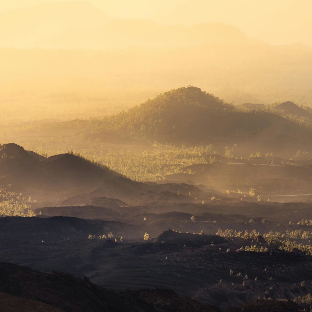
Tenerife: A trip to the volcanic heart of the Canary Islands
The Canary Islands, jewels of the Atlantic, are, in essence, the visible manifestation of intense volcanic activity that has shaped their landscape and identity over millions of years. Each island is a chapter in the great geological history, a testament to the unstoppable force of nature.
While all the Canary Islands have a volcanic origin, today we focus our attention on Tenerife, the largest and most diverse island in the archipelago. Its formation and current geography are a clear reflection of the powerful interaction between magma, water, and time.
Main image: Marek Piwnicki
Tenerife, the largest of the Canary Islands, is a destination where nature displays its power and beauty. In the heart of this volcanic island, Mount Teide rises majestically, dominating a landscape of craters, lava flows, and Canary Island pine forests.
This trip immerses you in a unique environment, where geological history intertwines with local culture, offering everything from spectacular trails to picturesque coastal towns. Tenerife is more than sun and sand; it’s an adventure into the fiery soul of the Canary Islands.

Credit: Maxim Berg
Tenerife Formation
Tenerife, a jewel of the Atlantic, was born from volcanic fury some 20-50 million years ago on the ocean floor.
According to the uplifted-block theory, magma rose from the Earth’s mantle through faults in the seafloor, forming pillow lavas due to rapid cooling upon contact with water.
These underwater eruptions, initially calm, became explosive as they approached the surface, accumulating materials that built the underwater island.
About 7 million years ago, at the end of the Miocene, three independent islands emerged: Teno, Anaga, and Adeje.
Over time, a second, more intense volcanic cycle, beginning 3 million years ago, unified these formations into a single island. This period gave rise to the Pre-Cañadas Edifice, followed by the Cañadas I and II Edifices, which reached over 2,500 meters and generated explosive materials, such as the Bandas del Sur.
800,000 years ago, gravitational slides formed the valleys of La Orotava and Güímar, while the Dorsal Mountain Range, the highest and most extensive structure in the archipelago, rose to 1,600 meters.
Finally, around 200,000 years ago, eruptions in the Las Cañadas Caldera raised the imposing Pico Viejo-Teide, crowning the present-day landscape.
This process, combined with erosion and the activity of a hot spot, sculpted Tenerife’s complex topography, with its ravines, cliffs, and valleys, creating a unique natural setting that continues to fascinate the world.
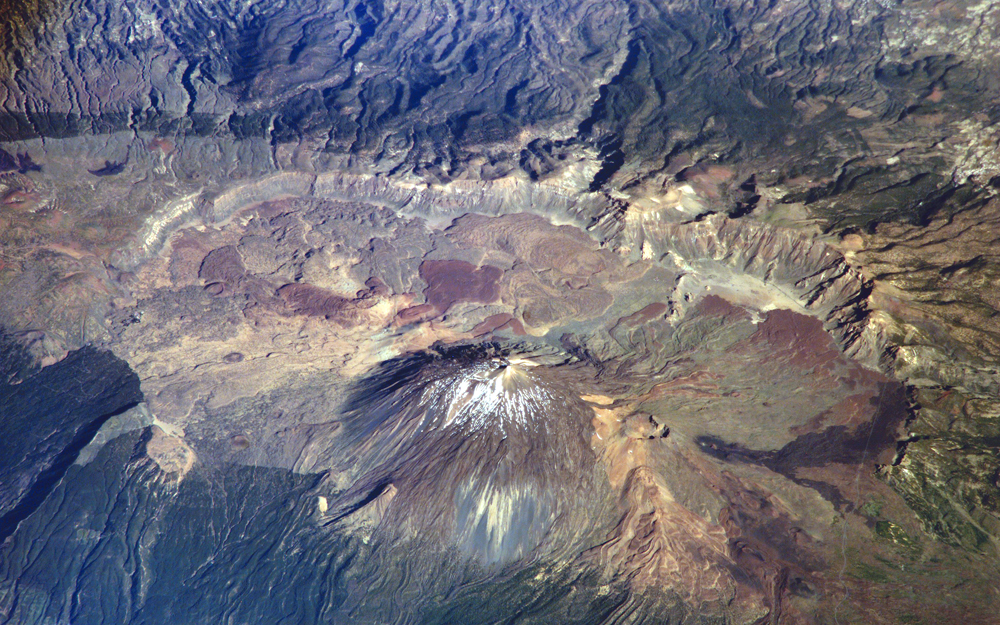
Photograph of Las Cañadas del Teide taken by an ISS crew member in 2006. Image Credit: NASA, ISS013-E-23272 (June 8, 2006)
Orography and Landscape: The Volcanic Imprint of Tenerife
Tenerife is a geological spectacle sculpted by millions of years of volcanic activity and erosion.
At its heart stands Mount Teide, at 3,715 meters, the highest peak in Spain and a symbol of the island. Nestled in Teide National Park, it is a lunar landscape of vibrant colors and unique formations such as Roque Cinchado and Los Azulejos, colored by hydrothermal activity.
The Las Cañadas semi-caldera, with Guajara Mountain (2,718 m) and the Llano de Ucanca, completes this central setting.
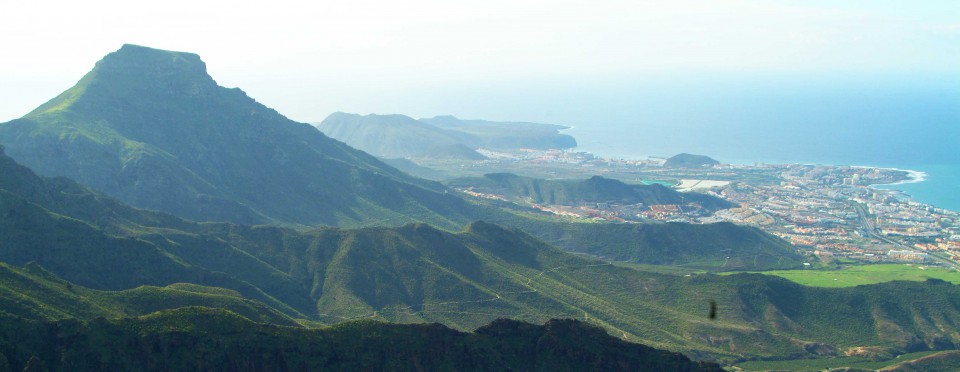
The island is diverse in ancient massifs such as Anaga, Teno, and Adeje, with steep terrain and deep ravines. Anaga, with the Cruz de Taborno (1,024 m), and Teno, with the cliffs of Los Gigantes (up to 500 m), are home to laurel and pine forests, while Adeje, with the Roque del Conde (1,001 m), shows a more worn landscape.
Roque del Conde. Image credit: Adeje Town Hall.
Ridges, such as the Cordillera Dorsal (up to 2,350 m in Izaña) and the Abeque Ridge, connect these massifs with volcanic cones and traces of historic eruptions, such as Chinyero (1909).
Valleys such as La Orotava and Güímar, formed by massive landslides, contrast with protected ravines such as Infierno. The coasts, steeper in the north with black sand beaches and gentler in the south with light sand, total 67.14 km of beach shoreline.

Orotava Valley. Image credit: Überraschungsbilder.
Furthermore, volcanic tubes like the Cueva del Viento, one of the largest in Europe, reveal the island’s subterranean legacy. This orographic diversity, from snow-capped peaks to cliffs and beaches, makes Tenerife a natural paradise.
Historical eruptions of Tenerife
Tenerife has a rich history of eruptions that have shaped its landscape and, in some cases, significantly impacted its inhabitants. Although Mount Teide is the first that comes to mind, many eruptions have occurred in different areas of the island, both within and outside Teide National Park.
It is estimated that Tenerife has 11 major volcanoes and more than 300 volcanic cones.
Boca Cangrejo Volcano – 1492
This is believed to be the first historical eruption in Tenerife and one of the first in the Canary Islands. Although its development is not well documented, the erupted materials are well preserved, offering a valuable object for studying historical eruptions.
Boca Cangrejo Volcano, located on the northwest ridge of Tenerife, approximately 2 km south of Chinyero Volcano (last erupted in 1909), is a Strombolian volcano with aligned eruptive vents and a main crater open to the west. Its flows, of intermediate basanitic composition and aphyric-vesicular texture, cover 6.89 km² with a volume of approximately 0.03 km³, extending southwestward.
Although the exact duration of the eruption is uncertain, its low-volume cone and limited dispersion of pyroclasts suggest brief and non-explosive activity.
Recent carbon dating (C14) under the lava indicates that it occurred between 1430 and 1660 AD (95% probability), linking it to an eruptive event described by Christopher Columbus on his first voyage to America. This has sparked debate about historical volcanism in the Canary Islands. Some of its lava flows and eruptive centers are located within the Corona Forestal Natural Park.
Boca Cangrejo volcano. Image credit: IGME (Geographic and Mining Institute of Spain).
Multiple eruptions of Fasnia, Siete Fuentes, and Arafo – 1704 to 1705
The eruption of Fasnia, Siete Fuentes, and Arafo is notable for displaying the fissure dynamics typical of the Canary Islands’ dorsal edifices. With intense pre-eruptive seismic activity, it was the archipelago’s deadliest eruption, making it crucial for assessing the risk of monogenetic eruptions.
The eruption generated the Siete Fuentes, Fasnia, and Arafo volcanoes along a stepped fracture over 10 km long. It lasted almost three months (December 31, 1704, to March 27, 1705), following an intense seismic crisis that began weeks earlier and caused severe damage in the valleys of La Orotava and Güímar, destroying more than 70 houses and a church and leaving at least 16 victims, the highest number of deaths in historical eruptions in the Canary Islands.
The eruption began with a 300 m fissure near the Diego Hernández wall, forming a small horseshoe-shaped structure.
On January 5, 1705, the Fasnia volcano activated a 1.3 km long fracture with scoria cones and flows that traveled 7 km through the Barranco del Volcán.
Finally, on February 2, the Arafo volcano, in the Pedro Gil caldera, produced flows that covered 3.75 km², reaching close to the sea in El Socorro. The associated strong seismic activity, felt in Tenerife and La Gomera, destroyed structures in Güímar, La Orotava, Los Realejos, and Candelaria.
This eruption is key to assessing volcanic risk in the Canary Islands due to its impact and dynamism.
Currently, the volcanoes are protected: Fasnia in Teide National Park, Siete Fuentes and Arafo in the Corona Forestal, and part of the Arafo lava flows in the Siete Lomas Protected Landscape.
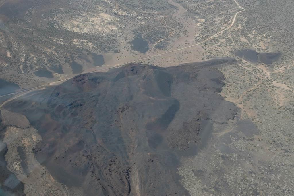
Image credit: IGME (Geographic and Mining Institute of Spain).
Garachico Volcano (Arenas Negras) – 1706
Although the main hazards of the Garachico eruption, also known as the Arenas Negras or Trevejo Volcano, were related to lava flows, this eruption is a clear example of how a low-hazard event can generate high risk due to favorable geographical conditions.
The Garachico eruption (May 5–June 13, 1706) was the volcanic event with the greatest socioeconomic impact in the Canary Islands, almost completely destroying the city and Tenerife’s main commercial port in the 18th century.
It emitted 0.045 km³ of volcanic material, covering 7.6 km². This basaltic fissure eruption, with a low explosivity index, developed along a northwest-southeast fracture.
Initially, it generated lava fountains that formed small spatter cones and pahoehoe flows, later evolving into a Strombolian style, with lava concentrated in the southeastern sector of the fracture.
Oil painting by Ubaldo Bordanova of the Garachico volcano eruption.
In less than 12 hours, the lava flows traveled 6.5 km, descending the northern flank of the NW ridge to a 500 m paleocliff, where abrupt changes in slope favored the formation of pyroclastic flows and accretionary rocks, increasing their destructive power. The lavas modified the coastline, shifting it 250 m.
Although the main hazards were lava flows, the event shows how a low-hazard episode can have high risk due to favorable geographical conditions.
The eruptive materials are protected in the Chinyero Special Nature Reserve and the Protected Natural Landscape of the La Culata Cliffs.
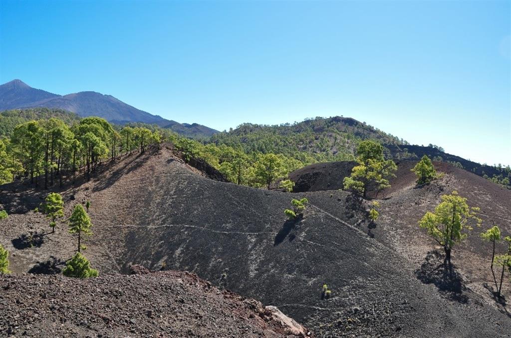
Chahorra Eruption – 1798
The Chahorra eruption (1798), the last within Teide National Park, occurred on the western slope of Pico Viejo and was the most violent and prolonged (June 9 to September 8) in Tenerife’s historical volcanism.
It emitted 12 million m³ of lava, contained in the Las Cañadas atrium. Known as the “Narices del Teide,” this basaltic fissure eruption, controlled by a NE-SW radial fissure of Pico Viejo, featured emission centers at different altitudes (more than 500 m in elevation in an 800 m fracture). This generated upper craters with degassing morphologies and lower craters with lava flows, adapted to the flank of the stratovolcano.
Although it is part of the monogenetic volcanism of the Northwest Ridge, its dynamics are influenced by the structure of the stratovolcano.
Today, the eruptive complex is protected within Teide National Park, the Teide Natural Monument, and is a Site of Community Importance, a Special Conservation Area, and a Special Protection Area for Birds.

Image credit: Léa Deleligne.
Chinyero Eruption – 1909
The 1909 Chinyero eruption, the last in Tenerife, was a highly explosive strombolian event with a significant socioeconomic impact. Its study is key to predicting risks on a densely populated island, improving geological models and predictive tools for future volcanic crises.
The eruptive centers, at an altitude of 1,500 m, formed in a 625 m fissure, creating an arc volcano due to the emission of olivine-pyroxene basaltic lavas, which traveled up to 4.5 km with a vertical drop of 500 m.
The eruption began with a violent phase, dispersing pyroclasts over 50 km, followed by a low-energy phase with alternating emissions of lava and ash, which covered the northern slope of Tenerife due to the action of the winds.
Well documented by witnesses, this eruption reveals a well-preserved volcanic landscape. The cone and lava flows are protected in the Chinyero Special Nature Reserve, recognized as a Site of Community Importance, a Special Conservation Area, a Special Protection Area for Birds, and a Natural Habitat of Community Interest.

Chinyero volcano, with Teide in the background. Image credit: Mataparda.
Teide-Pico Viejo Stratovolcanic Complex
The Teide-Pico Viejo Complex is the largest group of stratovolcanoes in the caldera. Mount Teide, a stratovolcano, grew rapidly, forming an asymmetrical cone with a semicircular base measuring approximately 5–2 km in diameter.
It rises from 2,000 m at Las Cañadas to 3,715 m at its crater. Its exact base is difficult to determine, as other eruptive processes have obscured its lower base.
Pico Viejo
The Pico Viejo crater, the most impressive in Tenerife, with a diameter of 800 m and a depth of 100 m, reveals a complex eruptive and destructive history that is key to understanding caldera formation.
Its Pliocene walls display tephriphonolitic flows and pyroclasts crossed by radial dikes. After the initial collapse, a phonolitic eruption formed a lava lake that overflowed, leaving terraces consolidated after the magma descended through flank eruptions.
A 300-m funnel on the western rim reveals a phreatic explosion due to the decompression of an aquifer during a lateral eruption, with surge and breccia deposits covering materials from previous eruptions.

Pico Viejo crater. Image credit: Marek Piwnicki.
Mount Teide
Mount Teide, a stratovolcano with a morphology divided into a large main mass and a summit cone, culminated its last eruption approximately 1,150–140 years ago with the Black Lavas, obsidian phonolitic flows emitted from the summit.
These lavas filled the La Rambleta paleocrater, a horseshoe-shaped depression 850 m in diameter and 3,555 m high, open to the northwest, and formed the current cone of Pico del Teide, 720 m in diameter, 160 m high, and steeply sloping.
At the summit, a semicircular crater 70 m in diameter and 45 m deep emits fumaroles of 86°C (186°F) containing gases (water vapor, CO2, sulfur, and nitrogen) and sulfur crystals by sublimation. These lavas have been exploited since the 16th century for agriculture and fireworks, limiting their current presence.
The black lava flows, emitted radially from the summit, reached their greatest extent on the northern flank, stopping at 690 m, while in the south they were diverted by a depression near Montaña Blanca.
These lava flows are notable for their lava channels, lateral outflows, and accretionary balls on Montaña Blanca, evidencing the eruptive dynamics of the Teide-Pico Viejo stratovolcano, the last recorded activity at this active volcanic complex.

Teide Peak. Image credit: Carolina de León.
The Volcanic Character of Tenerife: Legends, Adaptation, and Heritage
Volcanic activity has shaped not only the geography of Tenerife, but also its culture, myths, and way of life, turning eruptions into a creative force that defines the island’s essence.
Myths and Legends of Teide
The Guanche legend of Guayota tells how Guayota, the devil who lived in the Echeyde volcano (present-day Teide), was the cause of darkness and destruction. One day, Guayota kidnapped Magec, the sun god, plunging the island into perpetual night.
Desperate, the Guanches cried out to Achamán, their supreme god, who confronted Guayota. For days, the earth roared and the volcano spewed fire, reflecting the titanic battle. Finally, Achamán freed Magec and sealed the mouth of the Echeyde volcano, trapping Guayota inside forever.
This legend is a mythical depiction of a major volcanic eruption. It accurately describes phenomena such as darkness caused by ash, tremors and explosions, and the eventual return of calm and sunlight.
This story is most likely an oral account of Teide’s last major eruption, which occurred approximately 1,100–1,200 years ago, passed down through generations by a population that experienced the event firsthand.
Other stories speak of spirits in caves and wandering souls in the badlands, reflecting the respect and fear of nature that has shaped the island’s identity.
Adaptation to the Volcanic Environment
The inhabitants of Tenerife have adapted to their environment. The fertile yet demanding volcanic soils have given rise to crops such as vines, which grow in ash to retain moisture.
Volcanic rock defines traditional architecture, and underground galleries for collecting water demonstrate local ingenuity in the face of the challenges of the landscape.
A Living Heritage
Today, the volcanic landscape is a source of pride for Tenerife and a magnet for visitors. Teide National Park, a World Heritage Site, showcases lunar landscapes, lava fields, and caves that chronicle millions of years of volcanic activity.
This legacy not only sustains natural beauty and tourism, but also the resilience and spirit of its people, forged by the fires of the Earth.
In short, Tenerife’s volcanic history transcends the simple narrative of eruptions and geological formations; it is the heart of the island.
From its beginnings beneath the sea to the imposing presence of Mount Teide, every rock, every volcano, every ravine, and every setting reflects a fiery past that has shaped an island of unique beauty and astonishing biodiversity.
Understanding this profound relationship with the Earth is essential to fully appreciating Tenerife’s natural and cultural heritage, a vibrant legacy of the perpetual dance between nature and time.